Ok, so to be honest, it wasn’t two $100 Burger Runs. I only had a burger on the second run, the first one was for breakfast…
A favorite past-time for pilots is to hop in the plane and head to a neighboring airport to have a meal and then fly back. When you add up the price of the meal, the fuel burned, maintenance reserves (if it’s their own plane and not a rental), etc. and you are up over $100 easily. Hence, the name of the $100 Burger Run.
The People’s Republic of California requires a lot of money to keep running, so there are annual taxes to be paid on just about everything, including planes. There is an option if you have an aircraft that is 35 years old or older and meets certain other criteria that provides an exemption from that task if you have it on display at least 12 days out of the year. Many local airports host “Display Days” where you can fly in, park your airplane in the display area, and get a form signed off.
When I was based out of Corona (KAJO) I filled out the valuation forms with purchase price, etc… and turned them in to Riverside County. To my surprise (and satisfaction) they set the valuation at a much lower price then anticipated. The annual tax is based on that valuation, and it was low enough that I just paid the tax. I moved to Fullerton (KFUL) in January of 2019 and filled out the same forms with the same numbers and turned them in to Orange County. Much to my dismay, apparently “everything” is more expensive in Orange County and they decided that my plane is worth about 3x what Riverside County thought it was worth. With the much higher taxes I decided it was time to start participating in the “Display Days.”
Flabob (KRIR) Airport hosts “Display Days” on the third Saturday of the month. I called the restaurant to see if they were still serving food given the Governor’s latest round of closures in connection with COVID-19. They said that they are serving food outside on the patio. You have to wear a mask until you are seated at your table. It was a perfect opportunity to take a flight, get a sign-off, and have some breakfast.
The day before a friend had sent me a text “Are you open to a $100 hamburger on Saturday?”
If the morning marine layer which was forecast allowed, I planned to fly with my wife for breakfast at Flabob, and then make a mid-day run somewhere else with my friend for a second meal after the marine layer burned off.
I woke up a little after 6am with the sunrise coming in through the window, that meant clear skies to the East and as long as the ceilings were high enough at Fullerton (KFUL) we could take off and get to Flabob for breakfast. I picked up my phone and pulled up the app to check the weather in the LA Basin and much to my surprise all the airports were showing VFR weather with clear skies below 12,000′. The marine layer which was forecast never materialized.
Flabob (KRIR)
I headed to the airport to pre-flight and get everything ready. A hangar neighbor was also there pulling out his Beech Bonanza. My wife arrived shortly after that and I pulled the plane out and we climbed in. It fired up like clockwork on the third turn of the prop blade. After the run up and taxi we took off on 24, made a left turn, and departed climbing out to the east.
Flabob is a short hop to the East, just north of the Riverside airport. Passing Corona, I called up the Riverside Tower to request transition through their airspace.
Me: “Riverside tower, Mooney 78878, two thousand five hundred over the 91 – 15 requesting transition to Flabob with November.”
Tower: “Mooney 78878, transition approved at two thousand five hundred.”
I have been given transition at 2,000′ before, but he had multiple planes working the pattern at 1,800′ and wanted the separation. As soon as we passed over the runways at Riverside the tower removed the altitude restriction and gave us a frequency change so we could talk to the other traffic at Flabob on the UNICOM frequency.
Flabob only sits at 767′ elevation with a pattern altitude of 1,467′. We were only three miles away and at 2,500′ so I pulled power back to be able to descend to pattern altitude. We entered a left downwind for runway 24 ad extended the downwind to the East of Mt Rubidoux. When I was landing there during my PPL training we flew the Cherokee right at Mt. Rubidoux turning base west of the hill, but the Mooney doesn’t sink like a Cherokee, and I still needed to lose altitude anyway, so a base leg East of the hill just works better.
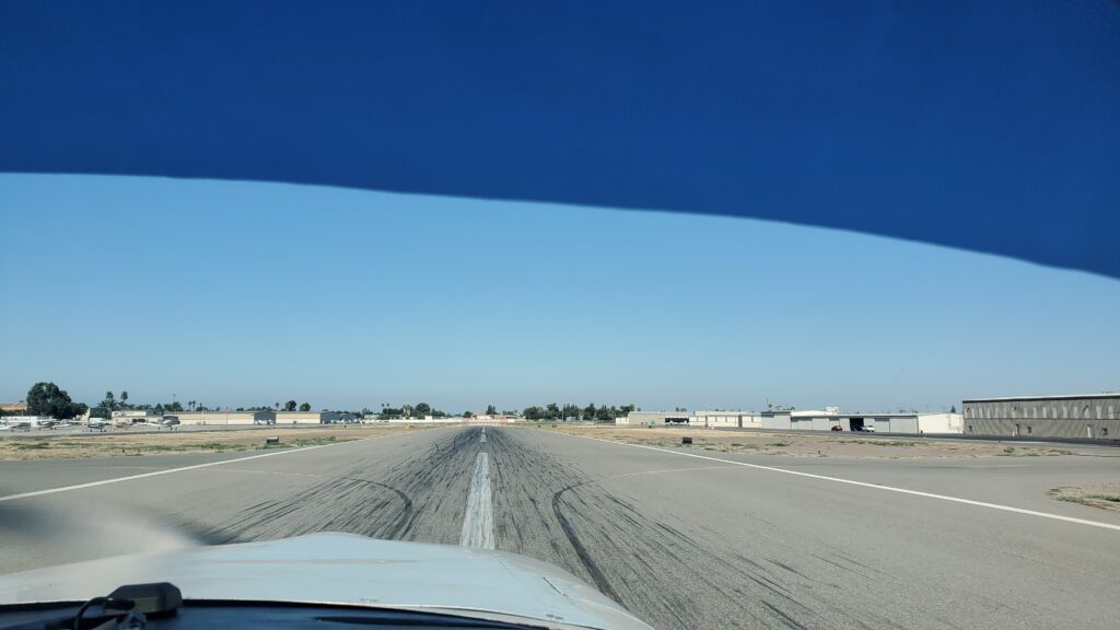
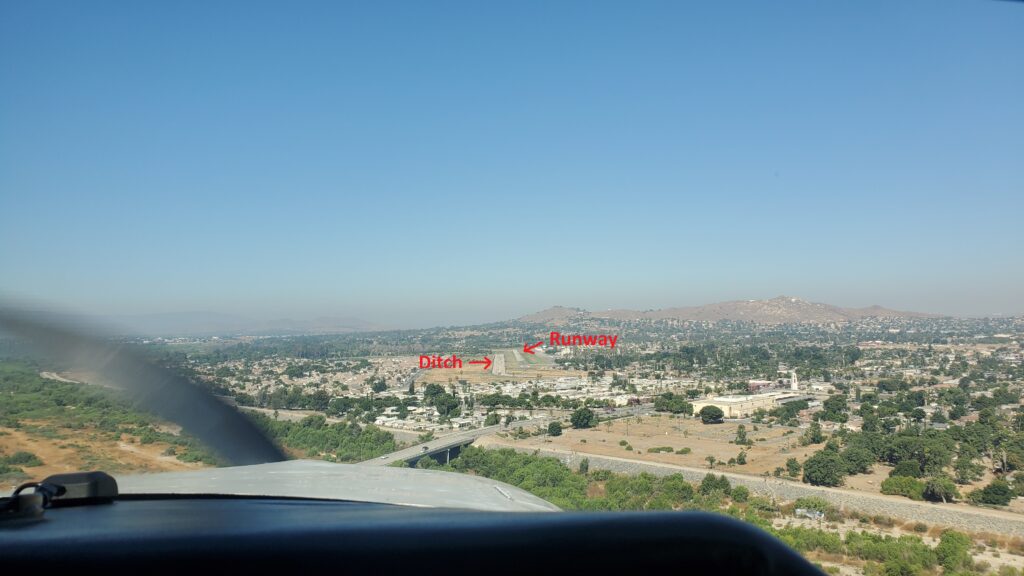
As I turned about a two mile final I got lined up, and then was trying to figure out what the dark square was at the far end of the runway. Was that something on the runway, and if so, what was it? The runway at Flabob is listed as “asphalt in poor condition.” It is a little bumpy, but the markings are almost non-existent, and part of it is newer asphalt which means it is a patchwork of colors. I continued to look at the dark shape at the far end and at about a mile and a half from what I thought was the runway I noticed I was lined up on the drainage ditch just to the left of the runway. I made the correction and we came in for a nice landing.
We taxied in, parked, got the sign-off, and walked over to the restaurant for some breakfast. The breakfast at Flabob may possibly be the best value around for the $100 Burger Run. I had a Denver Omelette with country potatoes and an english muffin. Kathy had their $2 breakfast taco (yes, you read that right, $2) and most of my country potatoes. Those of you who know me are aware it was not a sacrifice on my part to give up the potatoes…
We finished up a delicious breakfast and gave the waitress a healthy tip. When you know they are just trying to stay afloat with the restrictions from the government, and your breakfast was about the price of a couple of value meals, it’s the right thing to do. After having four separate inconsiderate pilots (a story to be told in a forthcoming post) blow dust and dirt all over everyone eating on the patio with their propwash we decided it was time to go.
The flight back was great. I had picked up the Riverside ATIS while on the ground and called up Riverside Tower for transition immediately after taking off. Riverside’s airspace is just 3/4 of a mile off the end of the Flabob runway so there isn’t much time to get the call in. We climbed up to 2,500′ for the flight back and twenty minutes after lifting off we were back on the ground in Fullerton.
As we taxied in and shut down my hangar neighbor to the East was taxiing in behind us. After putting the plane back in the hangar I helped him pull his Bonanza close enough to his hangar to reach it with his electric tug. I asked him where he had flown and he told me he had just had his Flight Review (it used to be called a biennial flight review or BFR because you must have one every 24 months). He also told me he is 83 years old. He said he’s been flying since he was 15 years old. I can only hope I am well enough physically and mentally to still be flying at 83 years of age.
Catalina (KAVX)


While Kathy and I were having breakfast I called out to the restaurant at Catalina to see if they were serving food. The lady that answered the phone said that indeed they were, you just have to wear a mask until you are at your table. I had texted my friend Michael that we were on for Catalina! I spent the time finishing replacing the pump in my home-made air conditioner which had broken off at the end of last summer. The weather at Catalina was going to be beautiful but it was getting warm in Fullerton and was supposed to be around 90 degrees when we were coming back. I also reviewed again the information and cautions about flying into Catalina.
Catalina (KAVX) is also called “The Airport in the Sky.” It is carved out of the top of a mountain and sits at 1,602′ elevation. There are some unique challenges to landing there given the location, the 2.1% slope, and the hump in the runway which prevents an aircraft at one end seeing one at the other. A normal traffic pattern will be flown at 1,000′ AGL (Above Ground Level). At Catalina as you are turning from right down-wind to right base out over the ocean instead of having the normal sight picture you are 1,600′ higher than normal so you must fly by the altimeter. The runway sits on a plateau and when the winds are coming down the runway it can create a downdraft on short final and if a pilot is coming in low and slow it can and has resulted in crashes into the hillside. The upsloping runway also presents a challenge of the optical illusion that a pilot is higher than they actually are which can lead to a low approach which coupled with the aforementioned possible downdrafts on short final can be problematic. Most flight schools that rent planes require a checkout flight prior to someone flying to Catalina on their own.
I have wanted to fly to Catalina ever since I got the Mooney. My first flight ever was supposed to be a discovery flight around Catalina but the island was socked in and it turned into a training flight instead. At first I didn’t go because the runway was not in good condition and I didn’t want to have my prop pick up any nicks. After the runway was redone I still needed life vests. I finally got life vests, and then the airport was closed due to COVID. Now, finally, I was going to fly to Catalina.
Michael arrived at the airport, I got the cameras all set up, already had the AC unit in the baggage compartment, we put on our life vests, and climbed inside. It was toasty, but as soon as I started the plane up we plugged in the AC and had a nice cool breeze coming from the back of the cabin.
After the run-up I talked through the flight, procedures on what to do in the event of having to ditch in the ocean, and then called up Fullerton Ground for flight following and taxi clearance where we ended up second in line on taxiway Alpha. After the plane in front of us departed there was landing traffic and then a Cessna over on Bravo that took off making right closed traffic. As that Cessna was on upwind we were cleared to depart.
Tower: “Mooney 78878, the Cessna’s in right traffic, runway two-four, cleared for take off.”
Me: “Two-four cleared for take off, 878.”
With that, I pushed the power in a little to roll onto the runway and get lined up, then pushed the throttle all the way in and we were on our way down the runway, lifting off just as we passed 70 mph and taxiway Charlie. The tower turned us over to SoCal Approach.
Me: “SoCal Approach, Mooney 78878.”
SoCal: “November 78878, SoCal Departure, roger, ident say altitude.”
Me: (I pressed the Ident button on the transponder) “Ident, climbing through one thousand seven hundred.”
SoCal: “878, radar contact south of Fullerton, own nav, climb approved, would you like forty-five hundred or higher?”
Me: “Looking for forty-five.”
SoCal: “Forty-five works, thanks.”
With that we began a right turn on course and continued our climb, leveling off at 4,500′ and heading out over the channel. It was beautiful! Initially we couldn’t see the island because of the haze but as we climbed above it the sky was clear and we could easily see the island about 35 miles away. It is a strange sensation out over the water at 4,500′, there is almost no sense of motion and it feels like you are barely moving.
We were handed off to the next controller and checked in. We were also monitoring the Unicom frequency for Catalina and could hear all the traffic arriving and departing, there were quite a few planes. It was only about a minute after checking in with the next controller before they ended our flight following.
SoCal: “November 878, there is about 8 targets around the vicinity of the airport so radar services terminated, squawk VFR, and advise you switch over to UNICOM frequency.”
Me” “Squawking VFR, going over to UNICOM, 878.”
We flew over Two Harbors and made a left turn to enter the right downwind for runway 22. One of the two helicopters working in the area for Edison was returning as we were flying our base leg and said he would stay southwest of the airport until after we landed. I told him thank you as we were turning final. I came in a little higher than normal and the approach was perfect. The touchdown? Well, it was a little hard, not my worst, but definitely more on the side of a carrier landing than greasing it in. I don’t know how bad the runway was before, but while it didn’t have potholes, it was rough, like driving down a concrete freeway that was not level from one slab of concrete to the next. I held the yoke back to keep the nose from bouncing up and down too much with the bumps. As we taxied to a parking spot I saw my friend Steve’s Bonanza parked on the ramp and he and his wife walking to the restaurant.
I think I am in love with Catalina. This is the first time I have set foot on the island, and it is beautiful. There is a nice cool breeze coming from the west, it is quiet with the exception of a plane or helicopter arriving or departing, and there is almost no development to be seen. I checked in at the “Tower” and inquired on the landing fee. Given the choice of paying per landing or getting a pass for the year I opted for the membership in the Conservancy and the annual pass. If I go there six times in the next year it will have paid for itself, I’m certain I will be there more than six times.
We caught up with Steve and Bobbi and joined them for lunch and then walked around looking at planes, talking to other pilots, and checking out the area where you can fly-in and camp at the west end of the airport. Before I knew it we had been there for four hours. I couldn’t believe how fast it had flown by.
We headed back over to the plane and I changed out the batteries in the cameras, hoping they would have enough juice for the flight around the island and back. We took off on 22, I kept the yoke back treating it like a soft field take-off, and we flew a right downwind, then turned a right base and descended down to 1,500′ as we flew clockwise around the island. There were boats anchored everywhere on the leeward side of the island.
The sights were amazing. The color of the water on the Pacific side of the island was so much brighter than the channel side, it almost looked like the color of the Caribbean. It was amazing to think as we flew northwest along the western coast that looking off to our right there was nothing but open ocean from here to Japan. Approaching the northern end of the island there were some clouds starting to from right at our altitude so we began a climbing right turn to get on course back and up to a safer altitude for crossing the channel.
We were about two thirds of the way back when we started descending to arrive at 2,500′ over Long Beach Harbor and requesting transition through Long Beach’s Airspace. I called up Fullerton at the normal reporting point above the 91/605 interchange and was told to enter a right downwind north of the KFI tower. Before we were even with the field we were cleared to land, but then he had a couple departures he wanted to get out so had us extend our downwind before calling our base turn and giving us landing clearance again.
It was a beautiful landing, you could barely feel when the wheels touched down. Michael commented on how nice it was, I said it is amazing the difference it makes landing on a level runway. We exited the runway and the tower gave us taxi instructions without asking where I was headed. It feels nice when you’ve been there long enough they know where you are going.
What a great day of flying!